
In China compasses have been in use since the Han dynasty (2nd century BCE to 2nd century CE) when they were referred to as “south-pointers”. However at first these magnets were only used for geomancy much like in the art of Feng Shui.
Eventually, during the Sung dynasty (1000 CE) many trading ships were then able to sail as far as Saudi Arabia using compasses for marine navigation. Between 1405 and 1433, Emperor Chu Ti’s Treasure Fleet of the Dragon Throne ruled the entire South Pacific and the Indian Ocean, a territory that ranges from Korea and Japan to the Eastern coast of Africa.
At this time Western mariners were still rather ignorant of the navigational use of the magnet. Petrus Perigrinus van Maricourt wrote a first treatise on the magnet itself: “De Magnete” (1269). And though its nautical use was already mentioned in 1187 by the English monk Alexander Neckham, the use onboard only came about around the 13th and 14th century in the Mediterranean Sea.
Much later, in 1545, Pedro de Medina (Sevilla 1493-1567) wrote the Spanish standard work “Arte de Navegar” on marine compass navigation. This masterpiece was first translated in Dutch (1580) and was -O Irony- used by Jacob van Heemskerk when the Dutch destroyed the Spanish fleet near Gibraltar in 1607. The drawback was of course Van Heemskerk’s own death during this victory.
Magnetic Variation
In the fin-de-siècle of the sixteenth century mariners believed that the magnetic north pole coincided with the geographic north pole. Any suggestion otherwise had been denied by Pedro de Medina.
Magnetic observations made by explorers in subsequent decades showed however that these suggestions were true. But it took until the early nineteenth century, to pinpoint the magnetic north pole somewhere in Arctic Canada (78° N , 104° W). From then on the angle between the true North and the Magnetic North could be precisely corrected for. This correction angle is called magnetic variation or declination.
It is believed that the Earth’s magnetic field is produced by electrical currents that originate in the hot, liquid, outer core of the rotating Earth. The flow of electric currents in this core is continually changing, so the magnetic field produced by those currents also changes. This means that at the surface of the Earth, both the strength and direction of the magnetic field will vary over the years. This gradual change is called the secular variation of the magnetic field. Therefore, variation changes not only with the location of a vessel on the earth but also varies in time.
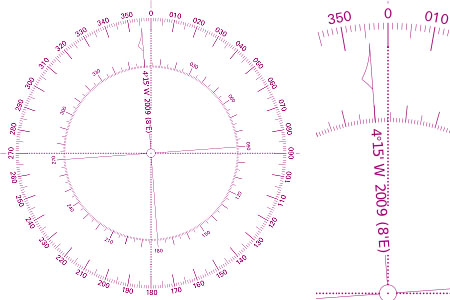
The correction for magnetic variation for your location is shown on the nearest! nautical chart’s compass rose. In this example we find a variation of 4° 15′ W in 2009, with an indicated annual correction of 0° 08′ E. Hence, in 2011 this variation is estimated to be 3° 59′, almost 4° West. This means that if we sail 90° on the chart (the true course), the compass would read 94°.
Another example: let’s say the compass rose gives a variation of 2° 50′ E in 2007, with a correction of 0° 04′ E per year. In 2009 this variation is estimated to be 2° 58′, almost 3° East. Now, if we sail 90° on the chart, the compass would read 87°.
Correcting for variation
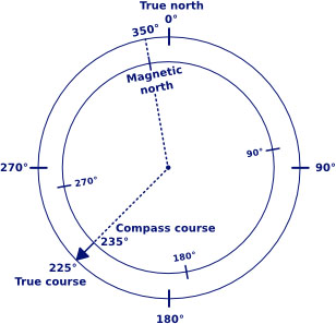
These overlayed compass roses show the difference between true north and magnetic north when the magnetic variation is 10° West.
Magnetic deviation
Magnetic deviation is the second correctable error. The deviation error is caused by magnetic forces within your particular boat. Pieces of metal, such as an engine or an anchor, can cause magnetic forces. And also stereo and other electric equipment or wiring, if too close to the compass, introduce errors in compass heading.
Furthermore, the deviation changes with the ship’s heading, resulting in a deviation table as shown below. The vertical axis states the correction in degrees West or East, where East is again positive.
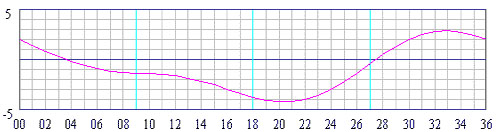
The horizontal axis states the ship’s heading in degrees divided by ten. Thus, when you sail a compass course of 220°, the deviation is 4° W. (Note, that on most modern sailing yachts the deviation is usually not larger than 3°).
When a compass is newly installed it often shows larger deviations than this and needs compensation by carefully placing small magnets around the compass. It is the remaining error that is shown in your deviation table.
You can check your table every now and then by placing your boat in the line of a pair of leading lights and turning her 360 degrees.
Correcting for both deviation and variation
Converting a true course into a compass course, we can still use our equation but we need to add the correction for deviation:
tc +/- var +/- dev = cc
Converting a compass course into a true course is a little less straight forward, but it is still done with the same equation.
cc +/- dev +/- var = tc
Magnetic Course
The magnetic course (mc) is the heading after magnetic variation has been considered, but without compensation for magnetic deviation. This means that we are dealing with the rewritten equation from above:
Magnetic courses are used for two reasons:
- To convert a true course into a compass course like we saw in the last paragraph.
- Bearings taken with a handheld compass often don’t require a correction for deviation, and are therefore useful to plot in the chart as magnetic courses.
Note, that the actual course lines the navigator draws in the chart are always true courses!
To summarise, we have three types of “north” (true, magnetic and compass north) like we have three types of courses: tc, mc and cc. All these are related by deviation and variation.
Glossary
- Variation: The angle between the magnetic north pole and the geographic north pole. Also called the magnetic declination.
- Secular variation: The change of magnetic declination in time with respect to both strength and direction of its magnetic field.
- West (-) , East (+): Western variations or deviations are designated with a negative sign by convention due to the compass card’s clockwise direction.
- Deviation: The error in compass heading caused by electric magnetic currents and or metal objects.
- Deviation table: A table containing deviations in degrees versus the ship’s heading (compass course) in degrees. Usually plotted in a graph.
- True course: Course plotted on the chart i.e. course over the ground or “course made good”. The course not corrected for compass errors.
- Compass course: The course (ship’s heading) corrected for compass errors.
- cc + var + dev = tc: This equation shows the connection between the compass course, its errors and the true course. It can also be read as: tc – var = cc + dev.