
Unravel the mysteries of astro navigation, using a sextant, ocean passage making, worldwide meteorology and electronic navigation aids.
This course is for those aspiring to blue water cruising and is ideal for holders of theYachtmaster Offshore certificate who are preparing for their first ocean passage.
Topics covered include:
- The earth and the celestial sphere
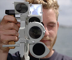
- Practical guide to use and care of sextant at sea
- Meridian altitudes
- Sun, star and other sights
- Ocean passage planning
Prior to the course your navigation skills should be at the standard of the Coastal Skipper/Yachtmaster Offshore shorebased course.
If you are working towards your Yachtmaster Ocean Certificate of Competence, completion of this shorebased course exempts you from the written exam.
The course is taught over 40 hours with one exam paper. It can be covered as a series of short sessions, as an intensive week-long course, or by distance learning
Maximum student:instructor ratio is 4:1
Courses are held here in our classroom at Wickford, Essex.
Full SyllabusThis is a course in astro-navigation and worldwide meteorology which also reveals the mysteries of the sextant. It assumes a knowledge of all subjects covered in the other shorebased courses.
1. The earth and the celestial sphere
Definition of observer’s zenith and position of a heavenly body in terms of latitude, longitude, GHA and declination Right angle relationships, latitude and co-lat, declination and polar distance Relationship between GHA, longitude and LHA Tabulation of declination in nautical almanac Rate of increase of hour angle with time
2. The PZX triangle
The tabulated components of the triangle, LHA, co-lat and polar distance The calculable components, zenith distance and azimuth Relationship between zenith distance and altitude Introduction to the tabular method of solution in the Air Navigation Tables and the basic sight form The use of calculators for the solution of the PZX triangle
3. The sextant
Practical guide to the use and care of a sextant at sea Conversion of sextant altitude to true altitude Application of dip, index error and refraction Correction of side error, perpendicularity, index error and collimation error
4. Measurement of time
Definition of, and relationship between, UT, LMT, standard time and zone time Rating of chronometers and watches
5. Meridian altitudes
Forecasting time of meridian altitude Reduction of meridian altitude sights
6. Sun, star and other sights
Reduction and plotting of sun sights using Air Navigation Tables Awareness of use of calculator for sight reduction The plotting of sun-run-sun meridian altitude Awareness of the reduction and plotting of sights obtained from stars, moon and planets
7. Compass checking
Use of amplitude and azimuth tables systems and/or calculator
8. Satellite Navigation Systems
Principles and limitations of use of all systems
9. Great circle sailing
Comparison of rhumb lines and great circles Vertices and composite tracks The computation of a series of rhumb lines approximating to a great circle by use of gnomonic and Mercator projections
10. Meteorology
General pressure distribution and prevailing winds over the oceans of the world Tropical revolving storms, seasonal occurrence and forecasting by observation
11. Passage planning
Publications available to assist with planning of long passages (routeing charts, ocean passages of the world and other publications) Preparation for ocean passage including survival equipment, victualling, water and fuel management, chafe protection, spares and maintenance
12. Passage making
Navigational routine Watchkeeping Crew management
13. Communications
Satellite and terrestrial systems Weather information